
Safety Survey taken January 2020
Below is a list of the 14 concerns the Lowry Pedestrian, Bicycle and Traffic Safety Committee had identified to be submitted to the City of Denver for review and response. With lower traffic volumes, and business closures due to the pandemic, the City will wait until October when schools and businesses fully open to study some of the areas of concern.
In Black Are the Questions as submitted to the City
In Red Are the Cities written responses, and/or additional summary of discussions with them.
Slides Provided by City for additional background for some questions.
Note: The City plans on implementing recommendations or to provide future studies for 7 of our top ten items.
Major Concerns (Questions 1-5)
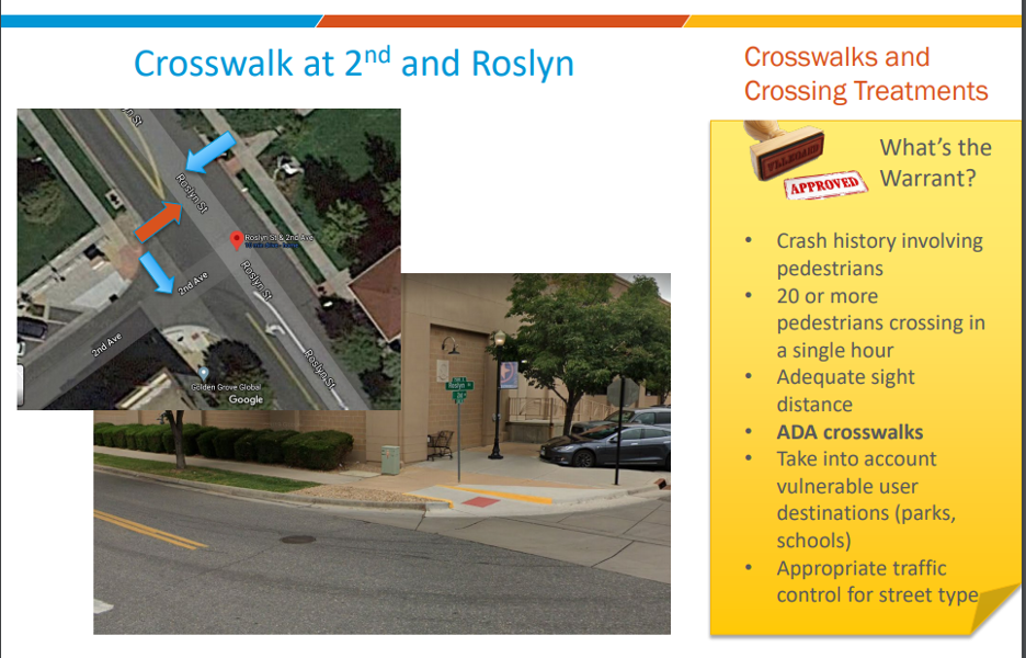
- Add striped crosswalks and possibly a 3-way stop at the intersection of 2nd Ave. and Roslyn Street between Safeway and the Chapel. Crosswalk is needed to cross Roslyn Street.
Crosswalks will be added in the East/West direction, but need to be placed in conjunction with rebuilding the ADA ramps at this location. In the picture below, you can see the ADA ramps only face across 2nd Ave, and need to be rebuilt to cross Roslyn Street also. The City may be delayed a bit on installation since sidewalk-specific funding needs to be identified for this. This may require removing the NB left turn lane on Roslyn St. A 3-way stop sign is not warranted. Will also look to see if a street light is needed at this intersection, which will help illuminate pedestrians.
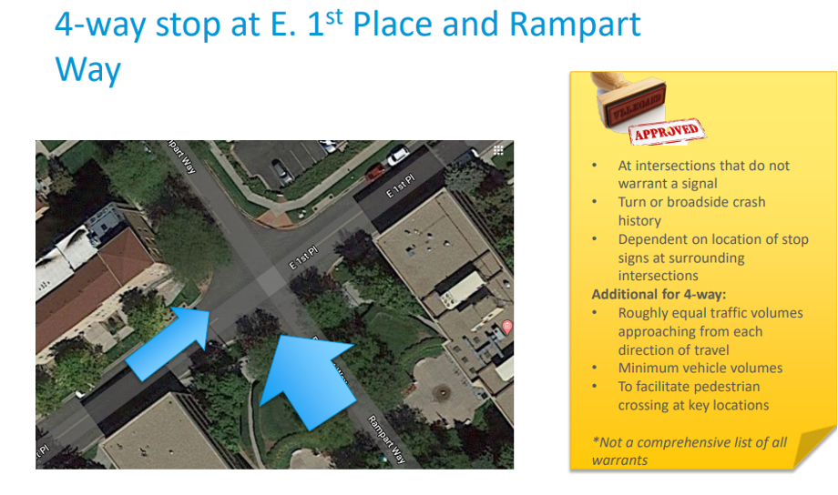
- Suggest a 4-way stop at E. 1st Place and Rampart Way. This intersection just feels like it is a 4-way stop. When stopped at stop sign on Rampart Way, parked cars often create poor sight distances in each direction for seeing oncoming traffic. Pedestrians walking on west sidewalk on Rampart do not see existing signs saying “Cross Traffic Does Not Stop”.
Traffic counts and accident history do not justify a 4-way stop. The city is cautious on installing 4-way stops, because they could be placed at numerous intersections. History shows that when too many 4-way stops are installed, people do not stop completely at signs, which makes the overall system less safe.
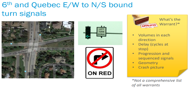
- Need left- turn signals and phases from 6th Avenue onto Quebec in both directions. Problems occur during AM and PM peak hours. For example: in the PM, EB traffic to NB Quebec is making turns on yellow about 50% of the time. WB to SB turns have poor sight distance for EB cars approaching Quebec, especially when EB left turning cars are stacked up. Observing the intersection though, it does seem to clear out fairly well, but often during the yellow cycle, extending into the red cycle. What is the traffic accident history?
Will review operation next fall at peak times when schools and businesses open. Will add “No Right Turn on Red” on EB 6th Avenue due to poor sight distance.
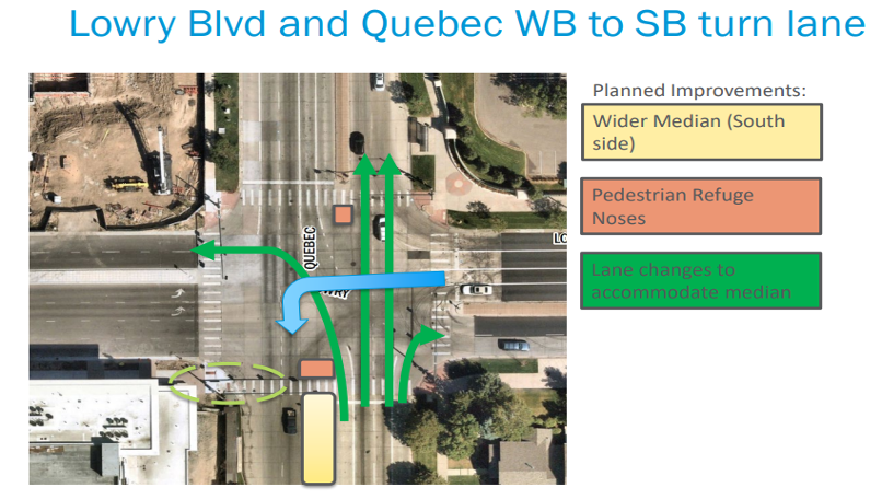
- Lowry Blvd and Quebec.
- Study if double left turn from WB Lowry Blvd. to SB Quebec Street is justified. Can striped unused area be used for 2nd left turn, or would cars in that striped area create a sight distance problem for the EB to NB turning movement?
Will look at extending signal turn time for WB to SB left turns, or adding 2nd WB turn lane (see blue arrow), but need to see how it effects EB left turn sight lines for WB through traffic.
Continue to monitor impacts as apartments and market area in Boulevard One are fully developed.
- All corners should have pedestrian push buttons for crossing, and crossing times should be reviewed. Check for push button on East side of Quebec crossing Lowry.
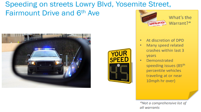
- Speed Concerns: LUN is working with Denver Police Officer Mike Borquez to monitor speeds.
To maintain lower speeds along Lowry Blvd, Yosemite Street, Fairmount Drive and 6th Ave, request periodic (every 3-4 months) deployment of digital speed signs/trailers. Note recent deployments:
a. Jan 2020 – EB Lowry Blvd. @ 9200 Block. Average speed: 36.48 MPH with a 35 MPH speed limit.
b. Nov 2019 – 300 Block Yosemite, Average speed: 31.42 MPH with a 30 MPH speed limit.
c. At both locations, just over 85% of people drove more than 5 MPH over speed limit.
The yellow box below shows a review when 85% drive at more than 10mph over speed limit.
d. Note: Approximately 62% of driver’s acknowledged speed signs and reduced speeds.
Pedestrian Related Educational Questions
When our Pedestrian, Bicycle and Traffic Safety Committee last had a major effort working with the City between 2015-2017, we also sent out quarterly informative flyers. These included information on Roundabouts, roadway speeds in Lowry, bike routes and safety tips, and information on school zones. We would like to provide some similar information again to those who attended the January presentation. In particular, we would like to provide additional direction on the following two themes:
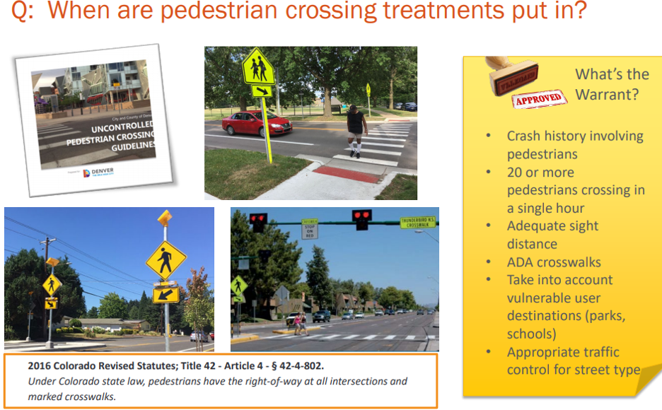
- When is it warranted or proper to paint pedestrian crosswalks at intersections? Many people wanted these at corners near them.
- When is it required (by law) for vehicles to stop for pedestrians crossing the road? What kind of crosswalk roadside signage or roadway striping indicates this?
Other Concerns
- Improve and add missing signage to address concerns identified for children crossing Fairmount Dr. at Cedar Place. There are approximately 25-30 kids from Lowry Park and Pilot House Apartments that attend Lowry Elementary. These apartments are SE of the intersection of Fairmount Dr. and Cedar Pl.
The city has indicated they most likely will provide an improved crossing and signage at Cedar Place – see bullets “a” and “b” below.
a. Need children crossing sign for SB Fairmount Dr. approaching Cedar Place. Currently, there is only an old faded sign for NB traffic approaching Cedar Place.
b. Add a crosswalk across Fairmount Dr. on the south side of Cedar Place. Leaving school, the sidewalk meets S Ulster St. on the south side of Cedar Place, and there is a crosswalk there. This just keeps the south side crossing consistent with the East side of Fairmount Drive.
c. In general, how far away from school does school-related signing extend?
We have not evaluated this before. We can run a pedestrian count to determine if a crossing treatment is warranted. For LUN–do you know what time most kids are crossing so we can collect those counts at the peak time?
School zone warning signs are posted in the block in advance of a school, usually ~200ft.
d. Would any of these improvements be covered under a “Safe Routes to School” program? How does a school qualify for this program? Our understanding is that the school needs a sponsor from the school to initiate the Safe Routes to School project. Also, I understand that there is an educational component and infrastructure component to the program and that the applications are typically due in September. Are these correct statements.
See slide on Safe Routes to School (SRTS). They have several larger programmatic approaches that may be helpful. You contact Lisa Diaz directly or submit a 311.
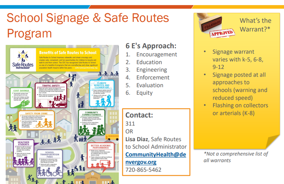
e. What triggers getting reduced speed for School Zone signage?
All schools should have school zone signs in the blocks on the approach. The nature of the signage various by school grade level and the type of street.
f. Review of pedestrian crossing of Fairmount at Sports Park Blvd. needed.
A crosswalk is warranted at this location based on recently collected counts. A crossing treatment work order is being prepared.
- Loss of the median left turn/suicide lanes along 11th Ave as a result of the bike lane installation causes backups, especially for high turn movement from EB 11th Ave. to NB Syracuse St. This is a highly used NB alternate for Quebec between 11th Ave and Stapleton. Concern is during PM rush hour beginning about 4 PM.
- Cars back up significantly behind EB left turn vehicles, since WB traffic is also heavy at this time. If left turning car is far enough left to pass on the right, vehicles will use bike lane to pass.
- Also, cars can no longer pass stopped busses along 11th without going across yellow stripe into oncoming traffic. They used to be able to use median turn lane area to pass.
We are evaluating this issue to determine the scope of the problem. As noted on the call, signalized intersections along 11th Ave were evaluated/modeled for impacts on left turning traffic and delay as part of the bicycle project. However, non-signalized intersections were not evaluated. Community members should contact 311 if extended delays or safety issues are arising.
- Eastbound 6th Ave at Quebec needs to have a sign added for “No Right Turn on Red” if justified. Sight distance is very poor if you stop at crosswalk/stop bar.
A no right turn on red sign is appropriate based staff sight visit and a work order for installation is being developed.
- Again, when it is warranted to place crosswalks at intersections. Intersections at Eisenhower Chapel, Crescent Park and new 1st Avenue stops west of Quebec were some of the identified potential locations.
Please refer to attached presentation slide and Crossing Guidelines document. This is between questions 5 and 6 above.
- On 1st Avenue between Monaco Street and Quebec Street
- Cross walks across 1st were not painted at new stop signs at Newport and Pontiac Streets. Going east and west on 1st Ave., new stop signs have “All Way” or “4-Way” signs under Stop sign, but side streets do not.
Based on previous analysis, both these locations can receive this treatment. A crossing work order is being prepared.
Ongoing Monitoring
- Continue to monitor NB to WB left turn from Rosemary to Lowry Blvd. Note: City did review this location in late 2019, and a signal was not yet warranted. When will it be studied again?
- Continued monitoring of the function of the Roundabout at Lowry Blvd and Uinta Way as 300 apartment units at Broadstone become occupied. East and West legs of roundabout currently have only one lane. At some point we may need two lanes for entire roundabout.
- Concern is that to go EB on Lowry Blvd, vehicles leaving must use most or all of roundabout.
- To get back into apartments going WB, they must get onto Uinta Way since raised median blocks exit along Lowry Blvd.
- Both of these require usage of 1-lane segments of roundabout.
Additional Items of General concern
- It would be good to add missing sidewalk segments along west side of Quebec between 6th Ave and 7th Ave (7-Eleven). Between E. 7th Ave. and E. Severn Pl., pedestrians walk in street gutter or parking lot.
- Although no Bollards have been installed in Lowry yet, there is concern about their placement if put in Lowry. Have turning radius templates been used during past installations to determine if trucks/busses can make turns. During recent snow storms, plows pushed snow off traveled roadway into area between the bollards and curb. This included the crosswalk area.